Maps and Family History
The map collection contains maps from across the United States of America. The following text will help you:
- Learn how to use maps in your family history
- Find out what types of maps are available in the map collection
- Learn how to search for a map in the map collection
- Search for a map
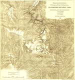
Maps are an irreplaceable part of family history research, especially if you live far from the location in which you are searching. To be truly helpful for family history, any map must show the geography and/or political boundaries as they existed when the ancestor you are researching lived there. Boundaries in the United States have changed constantly since the colonization of the east coast. Vermont, for example, was once part of New York.
Counties often started out large and then were divided, sometimes several times, as populations grew. Your ancestors may have lived on the same farm for two hundred years, but their records could be in five counties because of shifting borders. Maps from specific time periods will help you find those boundaries.
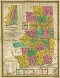
The map collection contains a variety of historical maps to aid your research. You can find maps depicting:
- U.S. state, territory, county, and city boundaries
- U.S. migration and transportation routes
- Distribution of various churches in the United States
- Indian reservation locations
- Ethnic populations in the United States
- Battles from the American Revolution and Civil War